15. From Vallouise to L’Argentière-la-Bessée via Col de la Pousterle (stage of the GR 54)
"It was not for nothing that Vallouise was voted ""the most beautiful village in the southern Alps""! Each little street, decorated with flowers, is an invitation for a stroll, and today is the last stage on this great adventure. These are two good reasons to take your time and walk slowly up Col de La Pousterle through the charming mountain villages of the Prés. The Pousterle refuge is an ideal place for reflection, before you return down to the Fournel valley and L'Argentière-la-Bessée, ending the journey on a high note!"
Description
From Place de la Fontaine in Vallouise (1 170 m), opposite the church, take the road on the left towards the Aiglière gîte.
- Pass the medieval oven and, at the next intersection, take Les Horts route on the left towards Pont Gérendoine (on the right is the GR54 route via Col de l'Aup Martin). The road passes through the orchards. After the campsite, turn left and go past the bridge (1 164 m).
- Continue along the road to Puy-Saint-Vincent and at the first hairpin turn, take the path as far as Les Alberts (1 380 m).
- Then turn right onto the road again and left at the roundabout towards Les Prés. Continuing along the road, pass under the departure point of the ski resort ski-lifts to reach Place des Prés. Opposite, on the right, the road passing in front of Maison Gautier leads to the Col de La Pousterle footpath along the cowpath.
- After crossing Prey d'Aval and Prey du Milieu, you arrive at Prey d'Amont along the footpath under the power line. It cuts across the bends in the road that can be seen in Prey d'Amont (1 629 m).
- Walk along the road and then, before the ascent to the mountain pass, follow the footpath that cuts across the bends in the road to reach the plateau and the vast Col de la Pousterle (1 763 m). Cross the plateau as far as its southern tip to reach La Pousterle gîte (1 750 m). Pass the refuge on the right and go down into the Fournel valley along the track and some shortcuts on the footpath. Pass the houses in Les Clausas and stay on the left-hand footpath (to the right is the Pas de La Cavale) as far as the bridge over the Fournel (1 350 m).
- Cross the mountain stream and follow the footpath along the right bank. It arrives at a route crossing a footbridge (EDF). Pass the Sapey bridge on the left and continue along the footpath in the Bois de Champ Pelbaud. Go past the footpaths leading to Col d'Anon and descend towards L'Argentière across the Magdeleine bridge (998 m).
- Turn right onto Rue du Château, which runs past the Silver Mine Museum. Then follow Avenue C.-de-Gaulle as far as L'Argentière-les-Ecrins station (990 m).
- Departure : La Vallouise
- Arrival : L'Argentière-les-Ecrins train station (L’Argentière-la-Bessée)
- Towns crossed : Vallouise-Pelvoux, Puy-Saint-Vincent, Les Vigneaux, and L'Argentière-la-Bessée
16 points of interest
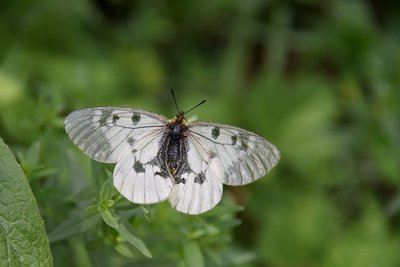
Le semi-apollon - Mireille Coulon - Parc national des Écrins  Fauna
FaunaThe clouded Apollo
This butterfly with hyaline (glass-like) translucent white wings, marked with two black spots, flutters around the clearing or the edges of the forest, where the host plants of its caterpillars grow: the corydalis. Although abundant locally, it is nevertheless a species in sharp decline and is protected.
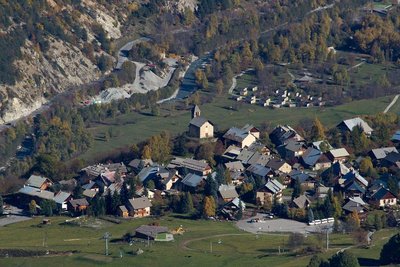
Vue sur Puy Saint Vincent - Christophe Albert - Parc national des Écrins  History
The Sentier du Facteur - the postman's path
In former times, the postman would take this path every day: He would set out from Vallouise, deliver letters in Puy-Saint-Vincent and drop back down to Vallouise, stopping at the hamlets of Parcher on the way. In the winter, when the snow was too deep, the Traversouires (the inhabitants of Puy-Saint-Vincent) donned their snowshoes and wielded their shovels to clear the postman's path down to Vallouise.
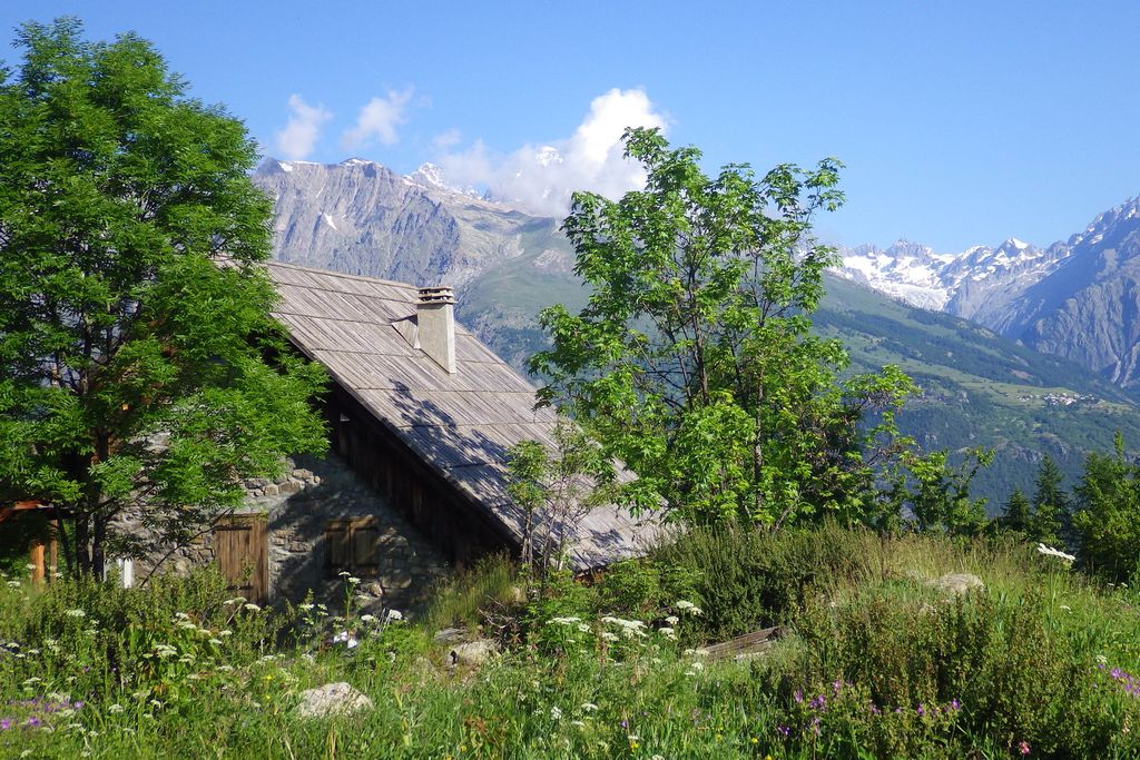
Hameau des Prés - Marie-Geneviève Nicolas - Parc national des Écrins HistoryLes Prés, hamlet of Puy-Saint-Vincent
Le Prés is one of the main hamlets of Puy-Saint-Vincent. Like Le Puy and Les Alberts, it stands on a flat plateau which is a glacial escarpment left by the now-retreated Gyronde glacier. Like Prey d'Aval, Prey du Milieu and Prey d'Amant, its name is a reminder that prior to the development of the ski resort, the land here used to be shared by meadows and crops.
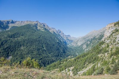
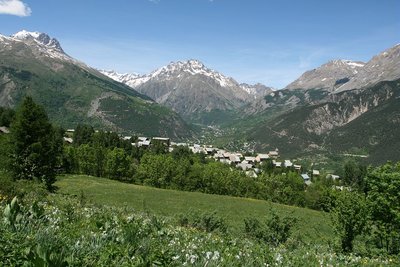
Vallon du Fournel vu du Col de la Pousterle - Jan Novak  Panorama
The Fournel valley
This is the southern side of the Col de la Pousterle and its view over the very long Fournel valley, known for its mines, ice waterfalls, blue thistles, its canyon and other treasures. Lower down is L'Argentière-la-Bessée. At the highest point, right in the distance, is the Champsaur!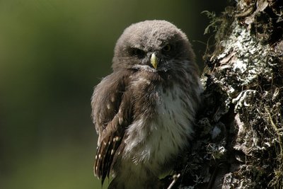
Jeune chouette chevêchette - Damien Combrisson - Parc national des Écrins FaunaThe Eurasian pygmy owl
The call of this small, nocturnal bird of prey can be heard in the spring, and also in the autumn when it can utter some peculiar sounds. Active during daytime hours and at dusk, the pygmy owl is a predator of passerine birds and small forest rodents. But when they spot it, passerines will come together in large numbers to mob it, so as to prevent any attempted surprise attack. It is restricted to mountain forests where it seeks out trees with woodpecker cavities in which it builds its nest.
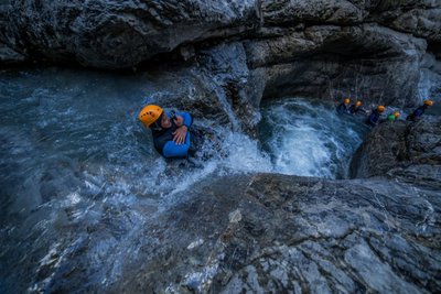
Canyoning - Fournel - Jan Novak Photography  Water
WaterThe Fournel
The Fournel mountain stream gives generously. Its water makes up a large proportion of the town's drinking water, supplies the irrigation canals, is used for hydropower and offers a recreational area valuable to the local economy in the form of its canyon, located in the gorge connecting it to the Durance. Being a mountain stream, it is impetuous, but sills have been built lower down and it has been dammed to prevent natural disasters. Numerous mountain streams have received the same treatment…
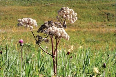
L'angélique sylvestre - Bernard Nicollet - Parc national des Écrins  Flora
FloraThe wild angelica
On the edges of seepage areas, the wild angelica grows. This is a tall umbellifer (the Apiaceae family) with blush white flowers and a hollow purplish stem. It is a cousin of garden angelica which grows in Northern Europe and is cultivated for its medicinal and culinary properties. The stem, the petiole (the «tail») and the leaf sheath can be candied.
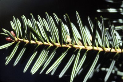
Aiguilles de sapin blanc - Parc national des Écrins FloraThe silver fir
A few coniferous trees, including the fir, are mixed in among the deciduous trees. The fir thrives on this north-exposed slope, called the ubac, because it cannot tolerate drought. Its flat needles are arranged on either side of the boughs rather than all the way around them, which distinguishes it from the spruce. They have two white stripes on their undersides. Its elongated cones stand upright, rather than hanging downwards.
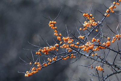
Baies d'argousier - Mireille Coulon - Parc national des Écrins FloraThe sea-buckthorn
Here and there, you come across a bush with narrow leaves which are green on their upper sides and silvery-grey underneath. Take care, the branches are spiky! In autumn, it produces acidic bright orange berries. They are very rich in vitamin C and are best as a syrup or marmalade. It is a pioneer species which colonises alluvial soils in sunny situations. It has also been used by the Mountain Terrain Restoration service to stabilise slopes prone to water runoff.
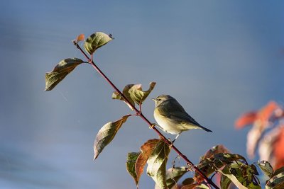
Le pouillot véloce - Mireille Coulon - Parc national des Écrins FaunaThe common chiffchaff
When spring arrives, a relentless «cheep, cheep» echoes around the forest. The singer is a small bird with a greenish grey and yellowish-white back, the common chiffchaff. Like other inconspicuous birds, the male has every incentive to make himself heard if he wants to attract the attention of a female! They are migratory and live almost anywhere where there are trees and bushes.
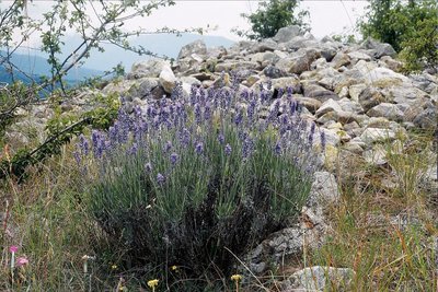
La lavande à feuilles étroites - Bernard Nicollet - Parc national des Écrins FloraThe lavender
As you drop back downhill, you are once again in dry, hot meadows. The narrow-leaved lavender is established here, a reminder that the Pays de Écrins is in the Southern Alps after all! Not to be confused with the lavandin, this plant naturally grows on the rocky slopes of the mountains of the Midi.
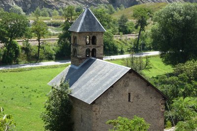
La chapelle Saint-Jean - Office de tourisme Pays des Écrins  Vernacular heritage
The chapel of Saint-Jean
Built in the twelfth century and listed as a Historical Monument, the chapel of Saint-Jean is of Romanesque style. Tombs cut into the rock were discovered in recent archaeological excavations.
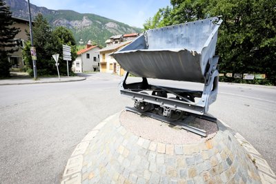
Un wagonnet - Jan Novak Photography HistoryThe Mines de Fournel rail-cars
Filled with materials excavated from the mine face, the rail-cars were pushed along the rails by the miners.
They were called “mine dogs”. They were originally made from wood and over time iron pieces were added. They were made entirely from metal by the end of the nineteenth century.
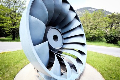
La turbine Francis - Jan Novak Photography HistoryThe Francis turbine
The American James Francis developed the Francis turbine between 1849 and 1855. It is a “àreaction” turbine suitable for medium-sized waterfalls (with a water head of between 15 and 500 metres). The water enters the turbine and then circulates between the turbine blades, which are fixed, while the inner wheel is mobile. The pressure at the wheel intake is greater than the pressure at the outlet.
Le compresseur mobile - Jan Novak Photography HistoryThe mobile compressor
In the mines, compressed air is used to remove dust and to create power for the drills. The mobile compressor holds compressed air in a resistant tank. This is brought to a high pressure via a pump (the compressor). The compressed air is then distributed to the mine machinery through a conduit system.
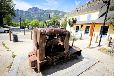
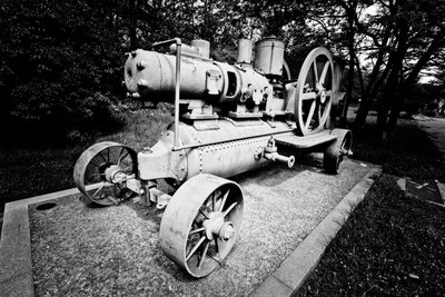
Le locotracteur - Jan Novak Photography HistoryThe light rail tractor
A locomotive? No, its little cousin, the light rail tractor. This replaced manually pushed carts and horse-drawn vehicles. Less powerful than a locomotive, it travelled along narrow-gauge tracks which could be laid on different types of terrain. An information panel also described the role of this vehicle during the Great War.
Altimetric profile
Sensitive areas
Peregrine falcon
- Impacted practices:
- Aerial, Vertical
- Sensitivity periods:
- FebMarAprMayJun
- Contact:
- Parc National des Écrins
Julien Charron
julien.charron@ecrins-parcnational.fr
Short-toed snake eagle
- Impacted practices:
- Aerial,
- Sensitivity periods:
- MarAprMayJunJulAugSep
- Contact:
- Parc National des Écrins
Julien Charron
julien.charron@ecrins-parcnational.fr
Short-toed snake eagle
- Impacted practices:
- Aerial,
- Sensitivity periods:
- MarAprMayJunJulAugSep
- Contact:
- Parc National des Écrins
Julien Charron
julien.charron@ecrins-parcnational.fr
Source

Report a problem or an error
If you have found an error on this page or if you have noticed any problems during your hike, please report them to us here: