4. Tour of Vieux Chaillol - Stage 4 out of 5
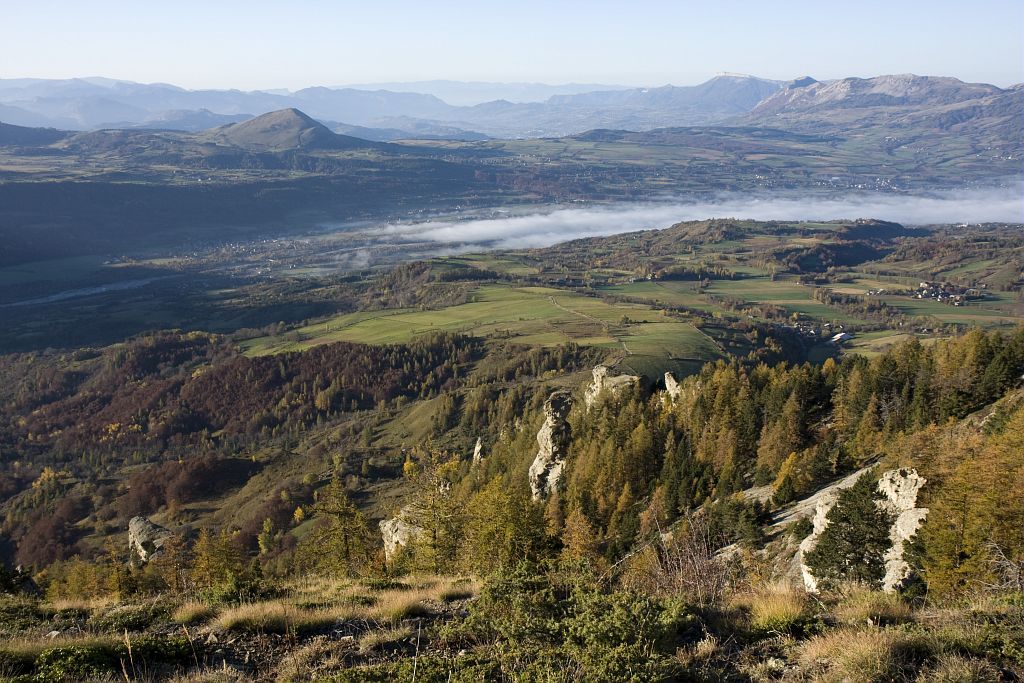
As well as a panoramic view of the Drac valley, you will discover a prosperous mountain, an area with a network of hedges, canals, sunken paths and its pollarded trees. There is an ongoing agro-pastoral tradition around the village resorts and in summer, most of the valleys and pastures are used for cattle and sheep.
Description
- An hour later, you will see a footpath to the left that goes down to the hamlet of Clapier. Continue up through the forest, the path flattens out to overlook the Aiguilles de Pertuis. Go through a shale zone and leave the forest for a pasture area where you may lose the tracks in some places. Take the footpath to the right, down along the thalweg up to the mountain spur that dominates the valley.
- Go down the meandering path that joins the small road leading to Les Richards. Walk across the hamlet.
- At the junction take the route to the left. Walk past a farm, through a first gateway, along the enclosure, through a second gateway and cross the Bonnets stream. The path then heads up the right bank and enters a wood, on a forestry path that goes down to, and crosses, the Brudou stream.
- Whilst still in the forest, go past the Baumette Forester's house, then not long after, above the Doue water source, cross over the Peyrousse stream.
- In the hamlet, turn right (sign) and follow the slightly downhill track. It soon reaches a crossroads.
- Follow the sign for Chaillol to the right. The trail climbs through the forest, sometimes a little steeply. Ignore the various paths on either side and follow the red and white GR markings.
- After a few steep switchbacks, turn left onto the balcony path towards Chaillol (sign). The GR comes to the forest again and follows an old irrigation canal just below. You will then reach the rest area of the old Chaillol mountain refuge.
- Follow the forestry road that goes down the right bank of the Buissard stream to get to the Chaillol resort.
- Departure : Les Borels
- Arrival : Chaillol 1600
- Towns crossed : Champoléon, Saint-Jean-Saint-Nicolas, and Saint-Michel-de-Chaillol
9 points of interest
Le village des Borels - Marc Corail - PNE  History
Les Borels
This is most important village in the Chamoléon district (no hamlet bears this name). Until towards the first world war in 1914, the valley lived in a closed circuit for all everyday items. At the Borels there was a weaver (wool and hemp), a miller-baker, an ironmonger, a mason, a breeches-maker and in the other hamlets, a cobbler, two millers, a joiner and two shoemakers. The latter worked from home.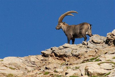
Bouquetin en été - Rodolphe Papet - PNE  Fauna
FaunaAlpine ibex
If you take a few minutes' walk at the end of the valley, you will be able to see some Alpine ibex. In September 1994, in Champoléon, some thirty animals from Vanoise area were released by Ecrins National Park rangers. This superb animal is heavier (100 kg) and less timid than the chamois, and is closely related to the domestic goat. It was almost extinct in the Alps. Today it is totally protected in France and is now safe extinction.
La vallée de Champoléon - Marc Corail - PNE HistoryChampoleon
To the 24 questions asked by the attorney general of the Dauphiné in 1789, the Champoléon Council replied, "Champoléon is in the most atrocious place of the Haut-Dauphiné. The community has 16 villages, 80 families and 600 souls spread over the slopes of the mountain. All of the roofs are thatched [...] the rivers and streams cause serious damage." Indeed, on All Saints Day in 1790, the Champoléon church was destroyed by flooding. Part of the graveyard was washed away taking coffins and corpses away from Champoléon too.
 Geology and geography
Geology
Upstream from Les Borels, the right-hand side of Champoléon is dominated by peaks without stratification, made up of crystalline rocks (granite and gneiss). They are protruding and pushing back the older, softer sedimentary rocks found on the other side (limestone and sandstone). These movements have caused faults and mineralisation which was exploited in past times (pyrite, galena, copper…)
 Vernacular heritage
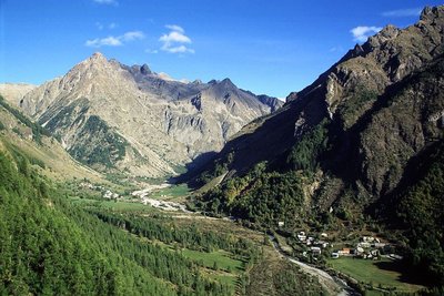
Les Richards
Perched up at an altitude of 1548 m above Pont-du-Fossé in the commune of Saint-Jean-Saint-Nicolas, the village of Les Richards is a haven of tranquillity. The view is breathtaking over the Autanes and the Champsaur woodlands. This is the starting point for a very popular hiking trail around the mountains or to the summit of the Palastre, and a take-off area for long-distance hang-gliders. It is not unusual for a hang-glider to land in Grenoble and sometimes even in Chamonix after a long day's flight from Les Richards! The record is 162 km, with a landing in Chamonix in 2002.
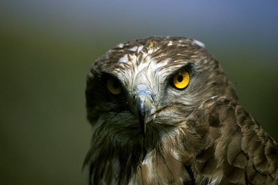
Circaète Jean-le-Blanc - Marc Corail - PNE FaunaShort-toed snake eagle
This bird of prey can be recognised because of its large head, its quite impressive wingspan (1.80m) and the white plumage under its wings and body. Despite its size, it rarely eat small mammals. Its food mainly consists of lizards and snakes. When it hunts, it takes up a particular position against the wind, poised in the air with its wings fully outstretched.
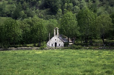
La Chapelle des Roranches - © Parc national des Écrins - Michel Francou Vernacular heritageLes Roranches Chapel
Built in 1780 on the site of a former chapel dedicated to Our Lady of the Assumption, the Roranches chapel is dedicated to Saint Pancras, the protector of farm animals and pets. It was built using humble architectural techniques, and is highly representative of the small places of worship in the Champsaur woodlands where, as so often in the mountains, the materials used were those that were ready to hand. Two renovation projects have been carried out on the chapel since 2013 with the support of the Ecrins National Park. The first was aimed at stabilising the barrel vault and renewing the framework and roof using the original material, slate. The second project was to restore the plasterwork inside and outside, as well as the whitewash, windows and flooring.
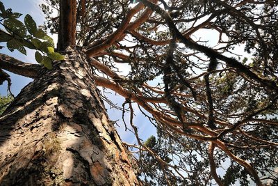
Vieux Pin sylvestre - Mireille Coulon - PNE  Flora
FloraScots pine
The Scots pine can be recognised by its long reddish brown trunk and sparse foliage. The needles are grey-green, slightly curved and paired. It needs a great deal of sunshine, but can make do with poor, sandy soil that is unsuited to other trees. Its wood is light and of high quality.
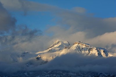
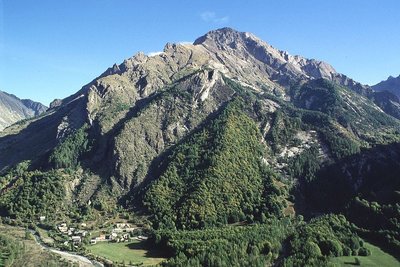
Le Vieux Chaillol, nuages et lumière du soir depuis Ancelle - Mireille Coulon - PNE Geology and geographyLe Vieux Chaillol
Easily visible from Champsaur and from beyond Gap, Le Vieux Chaillol is, like the Ecrins range, made up of granite rocks originating in the bedrock of the Cambrian era and which suddenly rose up some 5 million years ago. But the rocks of Le Vieux Chaillol have undergone a particular recrystallisation and have been transformed into metamorphic conglomerates and schists.
Altimetric profile
Sensitive areas
Golden eagle
- Impacted practices:
- Aerial, , Vertical
- Sensitivity periods:
- JanFebMarAprMayJunJulAug
- Contact:
- Parc National des Écrins
Julien Charron
julien.charron@ecrins-parcnational.fr
Peregrine falcon
- Impacted practices:
- Aerial, Vertical
- Sensitivity periods:
- FebMarAprMayJun
- Contact:
- Parc National des Écrins
Julien Charron
julien.charron@ecrins-parcnational.fr
Black grouse - winter
- Impacted practices:
- , Land
- Sensitivity periods:
- JanFebMarAprDec
- Contact:
- Fédération départementale des chasseurs des Hautes-Alpes :
Pierre-Frédéric Galvin : pierre-frederic.galvin@fdc05.com
Membre de l'Observatoire des Galliformes de montagne
Virginie Dos Santos : ogm.vds@gmail.com
Blandine Amblard : ogm.amblard@gmail.com
Recommandations
The Drac has very wide riverbed that spreads and flows in several branches. They can change direction after heavy rainfalls cutting off the cross-country ski trails in several places.
Information desks
House of Champsaur
05260 Pont-du-Fossé
Information and documentation, temporary exhibitions. Sale of products and works of the Park. In the same space, home office Tourist High Champsaur. Free admission. All animations of the Park are free unless otherwise stated.

Tourisme Office of Champsaur & Valgaudemar
Les Barraques, 05500 La Fare en Champsaur
Transport
In the summer, shuttle from Gap to Les Auberts that stops at Les Borels. Be sure to reserve 36 hours in advance at 05voyageurs.com or by calling 04 92 502 505.
Access and parking
From the N85, take the D944 (Col de Manse) 4 km after Pont-du-Fossé, turn left onto the D944a and continue to Les Borels.
Parking :
More information
Source

Report a problem or an error
If you have found an error on this page or if you have noticed any problems during your hike, please report them to us here: