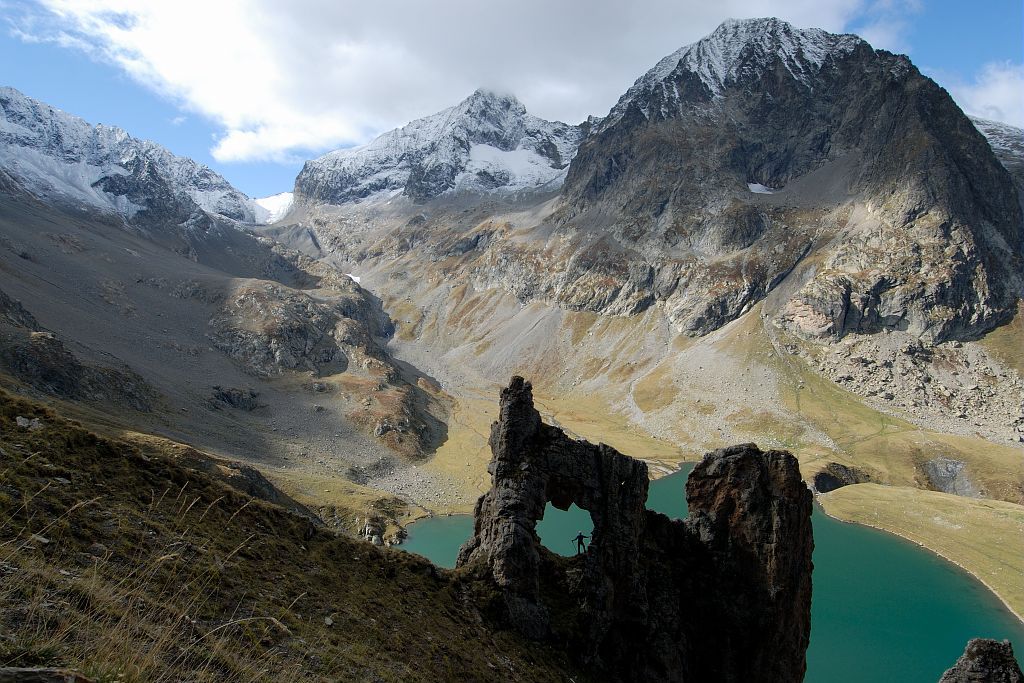
12. From Valsenestre to Lake Muzelle (stage of the GR 54)
The big day has dawned! The legendary Col de la Muzelle is beckoning. The climb towards the alpine pastures at the foot of the giants (Roche de la Muzelle, Pic du Clapier du Peyron) already sets the scene, this is a day for climbing! No less than 50 hairpin bends carved into the schist and regularly maintained, taking us up to the ultimate goal of this great adventure. A pure mountain experience, leading us to a haven of peace a little lower down: the banks of Lake Muzelle.
Description
From the Valsenestre car park, take the forest track that rises gently to the east. You can cross the mountain stream over two bridges in the forest, which is mainly made up of conifers (fir, spruce, larch), surrounding a few small meadows that are still mown today.
- Higher up, at an altitude of 1 492 m, turn left to reach the edge of the forest where you can a vast area of partially overgrown scree. Once you arrive at the Cantines cabin, the footpath climbs sharply along a steep slope where ewes graze in warm weather. On the opposite slope, you will notice an old footpath that winds its way up to reach the ""forge"", a cabin that has been carved out of the marble and the entrance of which can be seen. Half way up, you can see the pretty Ramu pastoral cabin to the left. The path is very steep in the last part (about 2 350 m), and you need to make your way across the schist thanks to the path's many twists and turns. From a distance, you might imagine there is an impassable wall ahead, but in fact it is easy to reach the high mountain pass (2 613 m) along the footpath, which is very well maintained.
- A short descent, which is steep at first, leads down to Lake Muzelle (2 130 m).
- Departure : Valsenestre, Valjouffrey.
- Arrival : Lake Muzelle, Venosc.
- Towns crossed : Valjouffrey and Les Deux Alpes
11 points of interest
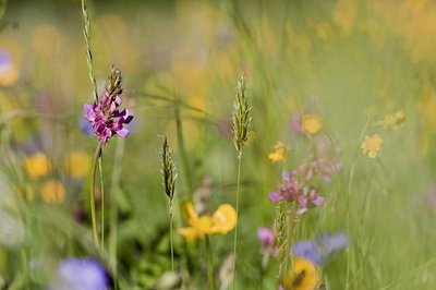
Prairie de fauche - Marc Corail - PNE  Flora
FloraNatural Hayfields
Agricultural specialists consider a meadow as natural if it has not been ploughed or fertilised over the last ten years. This is the case for those that you will see, surrounded by hedges, at the start of the hike. The meadows have an important variety of plant life and consequently attract multitudes of pollinating insects, including domesticated bees of course.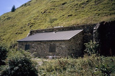
La cabane de la Cantine, Valjouffrey - Manuel Meester - PNE  Pastoralism
Cantine cabin
The dry stone (mortar) huts are an example of architecture without an architect they are the work, not of architects (unlike the religious, military and civilian buildings of the past), but of farmers and workers or masons whose names are now forgotten. These huts have many and varied names, which are mainly derived from regional languages, and which have been adapted into French. The Cantine (“Canteen” in English) huts were used as shelters for shepherds during the summer months, and probably owe their name to the meals eaten in the mountains.
Le front de taille de la carrière - Maurice Séchier  Geology and geography
Cipollino Marble quarry
From the 19th century, a cipollino marble quarry operated here. This marble had a white-green base colour with wavy green veins and a thick layer of mica. Les Cantines (canteen) hut is so-called because it was where the workers would have their meals. It was recently renovated and is used by the shepherd at the beginning and the end of the season.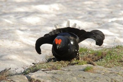
Parade de tétras lyre - Rodolphe Papet - PNE PastoralismPastoral management
From July to September, a flock of sheep occupy this steep valley. A shepherd watches over them and tends to them if necessary. Pastures are divided into sectors that are grazed upon according to a timeframe that takes the exposition and grass resources into consideration. For example, specific agro-environmental measures are in place to preserve the areas where black grouse nest. When the chicks are able to fly, usually after the 15th August, the sheep can head back to the area.
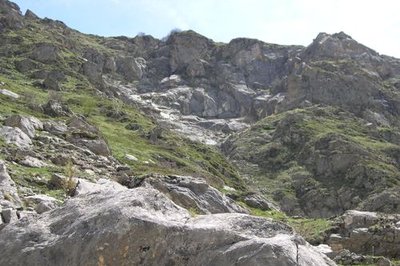
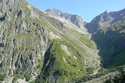
Roches moutonnées - Maurice Séchier Geology and geographyGlacier polished rocks
Around 15 000 years ago, the last glaciation ended. As it receded, the glacier left traces of its passage. Indeed, the withdrawal of such huge masses of ice polished the rocks and gave them a rounded shape, which is very apparent from the left bank of the valley. These rocks are known as 'moutonnées".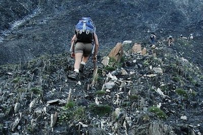
La montée au col de la Muzelle avant l'aménagement du sentier - Pierre Masclaux  Vernacular heritage
Maintenance of the footpath
After many complaints from hikers, the decision was made in 2010 to employ the necessary means to improve security on the route. It took a mechanical 'spider' digger a day and a half to climb all the way up to the pass. It then dug out the footpath as it went down the black shale on a 40° degree slope. Each year, serious manual work is undertaken to ensure that hikers have safe access.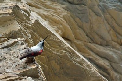
Tichodrome échelette femelle - Mireille Coulon - PNE  Fauna
FaunaWallcreeper
As you get to the last leg before the pass, you may well hear high-pitched whistles. If you are lucky, you will catch sight of the composer of this melody: the wallcreeper, which is a beautiful red, black and white bird. Defying verticality, the wallcreeper uses its long-clawed feet to latch onto the rock faces in search of insects and spiders. Its long beak then enables it to draw them out of the cracks in the rock.
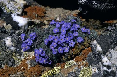
Eritriche nain - Bernard Nicollet - PNE FloraAltitude flora
Near to the pass, you will admire small grey-green cushions scattered with white flowers: this is the androsace helvetica, a rare protected species. This altitude plant is perfectly acclimatised to the hostile environment. This is also the case for the mountain saixifrage. Both like limestone, which is not the case of moss campion, small green cushion with pink flowers, or the Arctic alpine forget me not, a small blue-flowered plant that prefer the crystalline rocks here and there across the pass.
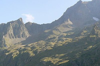
La vue générale sur la faille révèle le contraste des roches - Maurice Séchier Geology and geographyGeological impact
During this walk, the path takes you past brittle, black sedimentary rocks. At the pass, they come into contact with light-coloured crystalline gneiss: the contrast is surprising! There is a geological fault here where monumental forces have been pushing against each other for millions of years.
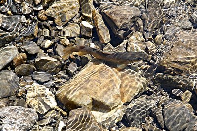
La truite fario - PNE - Telmon Jean-Philippe  Lake
LakeLac de la Muzelle
The Lac de la Muzelle is a glacier lake with cold waters, poor in life. The fish population is limited to salmonids (Arctic char, brook trout, etc.). Their active period is limited to summer. Since their food sources are low, they suffer from dwarfism. Each year, scientific monitoring is carried out by various universities and the National Park: samples of fish, phytoplankton, zooplankton and physical measurements.
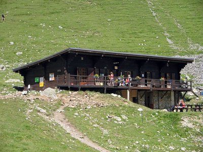
Le refuge de la Muzelle - PNE - Albert Christophe  Hut
HutMuzelle refuge
The bottom of the valley comes up to the rock wall at Muzelle, the pic du Clapier du Peyron and the head of the Muraillette. The modern history of this place is marked by mountaineering. It was on the 2nd July 1875 that Coolidge guided by Almer father and son opened the normal way to Roche de la Muzelle by the East North East face and the North-East ridge.. At this time, even if a pastoral cabin was used by the mountaineers the bivouac was still often used in the Muzelle valley. In 1967, it was in the rocky cirque that the community built the refuge on the shore of Muzelle lake.
Altimetric profile
Sensitive areas
Golden eagle
- Impacted practices:
- Aerial, , Vertical
- Sensitivity periods:
- JanFebMarAprMayJunJulAug
- Contact:
- Parc National des Écrins
Julien Charron
julien.charron@ecrins-parcnational.fr
Golden eagle
- Impacted practices:
- Aerial, , Vertical
- Sensitivity periods:
- JanFebMarAprMayJunJulAug
- Contact:
- Parc National des Écrins
Julien Charron
julien.charron@ecrins-parcnational.fr
Recommandations
Watch out for névé in spring in the last part of Col de la Muzelle, which may require the use of crampons and an ice axe.

Source

Report a problem or an error
If you have found an error on this page or if you have noticed any problems during your hike, please report them to us here: