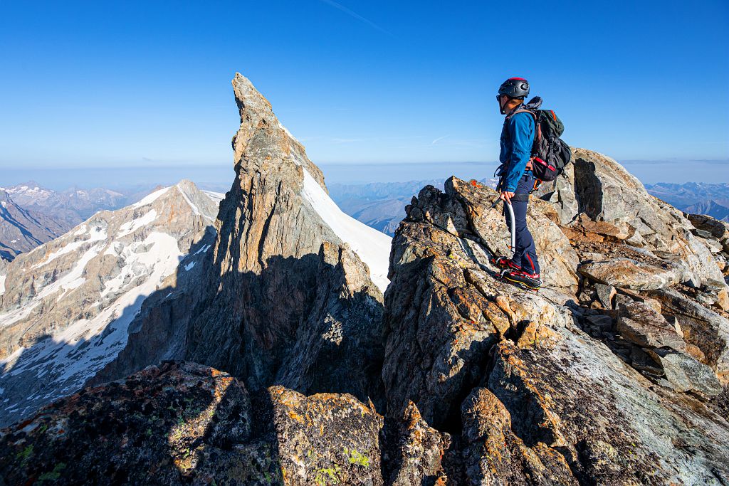
Meije Orientale from the Refuge de l'Aigle (mountaineering)
La Grave Hard
Hard
2. Meije Orientale from the Refuge de l'Aigle (mountaineering)
8h30
9,1km
+686m
-2434m
Stage
"Peu Difficile" (moderately difficult) – (40/45° on snow, II on rock/mixed), short but high-altitude climb, crevassed glacier, route frequently followed, the rimaye may be open and the first slope accessing the ridge may be ice covered.
Embed this item to access it offline
Climb an emblematic mountain of the Écrins on this beautiful out-and-back snow run from the Aigle refuge. The final ascent promises uninterrupted views of the Alps and the Écrins glaciers, as well as a chance to admire the south face of the legendary Doigt de Dieu.
Description
From the Refuge de l'Aigle, ascend the Tabuchet glacier (crevassed) heading for the Tête des Corridors. At a plateau, at around 3,600 m, traverse left until you have sight of the rimaye at the foot of the slope giving access to the north-east arête 3,670 m. After crossing the rimaye, ascend the steep slope (40°) until you reach the arête. Follow the ridge line, which does not present any difficulty, until you reach a rock island. Skirt around its right flank across rocks mixed with snow (II, 1 piton). Drop a few metres down into a pronounced rocky gap. Join the ridge of the snow-covered arête which rises stight up until it comes up against the base of a rocky outcrop (1 piton). Traverse this and ascend a steep snow triangle (45°) which leads to the easy, snow-covered arête running up to the summit.
Descent : Via the same route in reverse.
For more information, please refer to the book ‘Voies normales et classiques des Écrins’ by Sébastien Constant.
Descent : Via the same route in reverse.
For more information, please refer to the book ‘Voies normales et classiques des Écrins’ by Sébastien Constant.
- Towns crossed : La Grave and Villar-d'Arêne
Altimetric profile
Sensitive areas
Along your trek, you will go through sensitive areas related to the presence of a specific species or environment. In these areas, an appropriate behaviour allows to contribute to their preservation. For detailed information, specific forms are accessible for each area.
Golden eagle
- Impacted practices:
- Aerial, , Vertical
- Sensitivity periods:
- JanFebMarAprMayJunJulAug
- Contact:
- Parc National des Écrins
Julien Charron
julien.charron@ecrins-parcnational.fr
Recommandations
In the descriptions, you will find elevations which are intended as a reference point to locate your position on a gradient or slope. These should be taken with a margin of error (~ +/- 30 metres), especially where they are not set or referenced by the IGN. In the last resort, it is your own experience that will guide you when, maybe at the foot of five dihedral corners all indistinguishable from one another, you are complaining bitterly about your guidebook or even a friend's sketch. It would be difficult to grasp all the complexity of a route using just a description or a photo view of the route. Only the three aids together (description/photo with a route overlay/IGN map) will give you a comprehensive picture.
The conditions of a route or the mountain can change, and sometimes the description will differ from what you encounter on the ground. Be your own guide. These descriptions are not absolute reality and sometimes intuition will serve you better than a guidebook. So BONNE ROUTE, with or without a map to lead you through the maze!
From the book by Sébastien Constant (2007), Voies normales et classiques des Ecrins, Éditions Constant, L'Argentière-la-Bessée, p. 18.
Standard equipment for snow and mixed itineraries and glacial terrain: telescopic poles, crampons, ice axe, helmet, harness, 50m climbing rope, belaying and progress equipment, 30-litre bag, warm clothing, safety kit etc.
Is in the midst of the park
The national park is an unrestricted natural area but subjected to regulations which must be known by all visitors.

Information desks
Maison du Parc du Briançonnais
Place Médecin-Général Blanchard, 05100 Briançon
Located at the foot of the medieval town fortified by Vauban, declared World Heritage by UNESCO in 2008, the Maison du Parc Briançon is a welcoming place of information exchange. Three floors of exhibition to discover : the natural and cultural heritage, the museum of the history of skiing in Briançon. Documentation, maps, guidebooks, books and products of the Park. Guided tours for groups by reservation. Free admission.
More information
Source

Parc national des Ecrinshttps://www.ecrins-parcnational.fr
Report a problem or an error
If you have found an error on this page or if you have noticed any problems during your hike, please report them to us here: