4. From Le Lauzet to Col du Lautaret
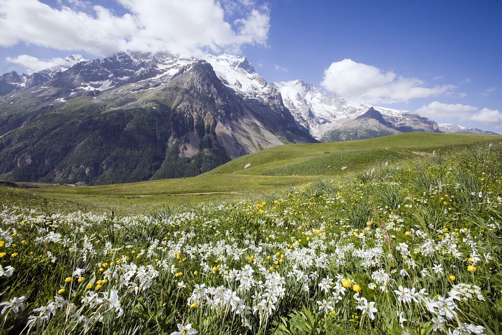
This fairly easy stage continues on its way, leaving you the time to enjoy the rich architectural and religious heritage of the valley. In the background, you hear the gentle purring of the Guisane, which also brings freshness and serenity to warm summer days. The path rises gently into the mountain pastures, in the footsteps of travellers from yesteryear, who found refuge in the hospices and walked through the pass in all conditions.
Description
- The GR runs along a passable track that gradually rises through the valley, on the left bank of the Guisane.
- At the former Madeleine hospice and chapel, the track turns into an easily recognisable footpath. You draw closer to the col little by little through the Alpine pastures, below the road to Le Lautaret. After a few wide, fairly steep turns, you finally arrive at the Col du Lautaret !
- Departure : Le Lauzet
- Arrival : Col du Lautaret
- Towns crossed : Le Monêtier-les-Bains and Villar-d'Arêne
6 points of interest

 Vernacular heritage
Madeleine Hospice
At an altitude of 1,810 m, below the present-day Col du Lautaret road, the Madeleine hospice helped travellers cross the pass in all weathers and provided pilgrims with a chance to rest on their way to Rome or the Holy Land. The foundation of the order of the Holy Penance in these buildings dates from 1228. There is a chapel on the site, and it is located on a former road from Briançon to Grenoble. An avalanche destroyed the Madeleine hospice in 1740, and the building was rebuilt, then abandoned, when the road to Lautaret was modernised.
 Panorama
View over the Pic de Rochebrune
The Guisane valley descends towards Briançon to the south-east. The view opens up in the distance towards the Massif du Queyras, with one of the summits clearly visible. The Pic de Rochebrune, at an altitude of 3,320 m, stands proudly above the Cervières valley, 10 km from Briançon and from the Guil valley in the Queyras region, linked by the Col de l'Izoard (2,361m). This enormous dolomite rock bastion is accessible to experienced hikers, since the last part is somewhat steep and you need to use your hands to climb up in places.
 History
Le Massif de Combeynot, W. Brockedon
In the work by W. Brockedon, Illustrations of the Passes of the Alps, published in 1828, one of the engravings illustrating the Col du Mont-Genèvre shows, according to the title: Mont d'Arcines and the Val de Guisane from the Col du Lautaret (p. 25). The view is described as follows: "Across a deep ravine, the River Guisane is seen tumbling down the mountains from its source in the distant glacier of Mont d'Arcines, and thence flowing on to the Durance, through the narrow valley which is bounded by rugged and pinnacled mountains ". On the previous page, it says that "Le Casset is near the foot of the Glacier de Lasciale, which descends from the Mont d'Arcines". So it is clear that Mont d'Arcines is the present-day Les Agneaux mountain, and the Lasciale glacier is the Casset glacier, which must have reached much lower down. However, Paul Guillemin thinks that this is the first printed depiction of La Meije, and he marks it as n° 2 in his inventory (PG: 2). This was an error of interpretation on his part. In fact, it is the view over the Massif du Combeynot from the old Lautaret road. From this viewpoint, Les Agneaux (or Mont d’Arcines) cannot be seen.

Le col du Lautaret vu depuis Laurichard - © Parc national des Ecrins - Cyril Couriser  Pass
PassThe Col du Lautaret climate
The Col du Lautaret is a climatic limit between the northern and southern Alps. It works like a barrier for rough weather, and it is not unusual that the Romanche valley to the west is filled with snow, while the Guisane valley to the east is dry, and vice versa. The Romanche valley runs down directly to the region of Grenoble, where the climate at the same altitude has twice as much precipitation, and so works as a corridor for rough weather coming from the area. This explains why the Col du Lautaret and the neighbouring Col du Galibier mark the limit for many plants with Mediterranean affinities. This transitional position is characterised by a climate with a strong Mediterranean influence in the direction of Briançon.
 Geology and geography
The tuffaceous ground of the Col du Lautaret
Tufa is a sedimentary rock produced by the precipitation of limestone dissolved in water, which comes to the surface from a water course or spring. In the course of this mineral solidification of carbonates, a great deal of plant or animal debris is trapped and becomes fossilised. This is how an excavation operation carried out between 2008 and 2010 was able to reconstruct the flora on the pass when the rock was deposited long ago. Tufa is also a soft rock which can be sculpted easily and was highly valued for the construction of public buildings or the houses of local dignitaries. The church of Villar d'Arène is built from tufa from the Le Lautaret quarry, a resource it almost exhausted. The tufa zone of Le Lautaret is listed as a habitat of community interest within the Natura 2000 site «Combeynot Lautaret Ecrins».
- Vernacular heritage
Marionnaise snow fence
In the Guisane valley, the Col du Lautaret road is in places highly exposed to the risk of avalanches. From when it was first built, a number of measures were taken. The first was a long, semi-open snow fence that lets snowslides flow above the road and arrive lower down the slope. A little further downstream is another, quite original solution: since the layout of the land was not adapted to a traditional snow fence, two diversion tunnels were dug at the sides (the Rif Blanc and the Vallois). If there is a major avalanche risk, the road is closed and the traffic temporarily diverted through the tunnels. Once the risk is over, the road is cleared and reopened to traffic.
Altimetric profile
Sensitive areas
Peregrine falcon
- Impacted practices:
- Aerial, Vertical
- Sensitivity periods:
- FebMarAprMayJun
- Contact:
- Parc National des Écrins
Julien Charron
julien.charron@ecrins-parcnational.fr
Information desks
Information center "Col du Lautaret" (summer only)
Col du Lautaret, 05220 Le Monêtier-les-bains
Under the gaze of the Meije (3983 m) and surrounded by beautiful meadows celebrated in the great names of botany, the former hospice of the Lautaret called "refuge Napoleon" houses the reception and information Park center - Projections, documentation, books of the Park. Accessible to people with reduced mobility. Free admission.
Source

Report a problem or an error
If you have found an error on this page or if you have noticed any problems during your hike, please report them to us here: