
1. From Col du Lautaret to Alpe du Villar-d'Arène
The path leaves the Col du Lautaret behind to join up with the Crevasses path. The landscape is wide open and impressive, La Meije proudly towers over the other mountains. In the distance, the former farming terraces above the villages of La Grave and Villar d'Arêne, and the flocks passing by, bear witness to the pastoral tradition. The walk along the Crevasses path is striking and the immersion in the high mountains begins with a first night in Alpe du Villar-d'Arène, at the heart of the Ecrins National Park.
Description
From the Col du Lautaret car park, the path makes its way towards Meije (3,983 m). Follow the signs to the “Sentier d'Interprétation des Crevasses”. Take the right-hand fork, leaving behind the Combe de Laurichard path (signposted). Take the footbridge up the hillside.The path has been adapted to cross several streams and goes through an area of bushes leading to a more open area, where it arrives at the Belvedere de L'Homme (exceptional view over the high mountains of Les Ecrins). Soon after, go through (and close) a barrier before going down the sometimes uneven schist slopes of a path called Les Crevasses (be careful, use the handrail). You then arrive in Alpe de Villar-d'Arène, and the path joins the GR 54. Soon after the weather station, leave the GR 54 and make a right before continuing straight ahead along a nice path as far as the two refuges in Alpe de Villar-d’Arêne.
- Departure : Col du Lautaret
- Arrival : Alpe du Villar-d'Arène
- Towns crossed : Villar-d'Arêne
9 points of interest
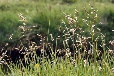
Hierochloe odorata - Bernard Nicollet - PNE  Flora
FloraHierochloe odorata
Also known as bison grass or sweet grass, this plant grows in wet grasslands and near fens. From its rootstock, it forms tufts between 60 and 70 cm high. Thanks to the coumarin inside it, it gives off a pleasant aroma, so that it is used to make distilled drinks. It is protected nationally and is also very rare in the Hautes-Alpes department.
Avant le démantelement des téléskis - Eric Vannard - PNE  History
Dismantled ski-lifts
A small ski resort was created in 1970 not far from the Lautaret mountain pass. Due to the risk of avalanches and new standards required, alpine skiing was moved near to the village of Villar d'Arène and Chazelet hamlet. The two obsolete ski-lifts situated in this very picturesque territory, rich in terms of biodiversity, ruin this place which has been classified since1974 as the national nature reserve of Combeynot. In 2013, dismantling was carried out by the Mixed union of ski-resorts in the Haute Romanche with the support of the National Park. In the end more than 35 tons of iron and concrete blocks were evacuated.
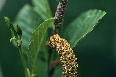
Chaton mâle et chaton femelle de l'aulne vert - Bernard Nicollet - PNE FloraAlder forest and green alders
Here is a spectacular transition from the genuine forest and pastures of the north facing slopes. There is a thick grouping of shrubs made up essentially of willows and green alders. These will never reach the size of a tree. They constitute impenetrable thickets where, over time, boars, chamois and roe deer have outlined a maze to hide in. The plants provide nitrogen through their roots and fertilise the soil, as if getting their own back on the eutrophic tall herbs.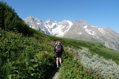
Le sentier traverse la megaphorbiaie. - Pierrick Navizet - Parc national des Ecrins FloraTransition zone at the upper edge of the forest, it has large plants with big leaves that seek light in order to grow. Under cover of their leaves, some animals and plants find a safe haven, particularly alternate-leaved golden saxifrage and adenostyles alpina. On the east part of the Ecrins massif, eutrophic tall herbs can be found at the edge of streams and brooks. Just after snowmelt, it raises its golden head and constitutes a lovely carpet of flowers.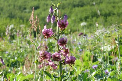
Le lys martagon - Pierrick Navizet - Parc national des Ecrins FloraTurk's cap lily
The Turk's cap lily lodges on the grassy slopes, meadows and undergrowth. It can be seen from a distance due to it long upright flowering stalk from which stem three to ten majestic flowers. They are large, purple-pink with some crimson, and have six petals that turn upwards when they reach maturity. Six orange stamens are then visible. The flowers that bend downwards lift when the fruit is formed.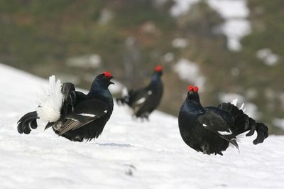
Parade de Tétrs Lyre au printemps - Robert Chevalier - Parc national des Ecrins  Fauna
FaunaBlack Grouse
The black grouse lives above 1200 m, and can only be found in the Alps. It is possible to spot the male due to its black plumage and its tail in the shape of a lyre (which is why its French name is Tétras Lyre). While it spends most of the time in winter in an igloo scooped out of the snow as protection against the cold, in the spring it performs spectacular parades to attract a female. The National park is tracking the population of the species in this zone.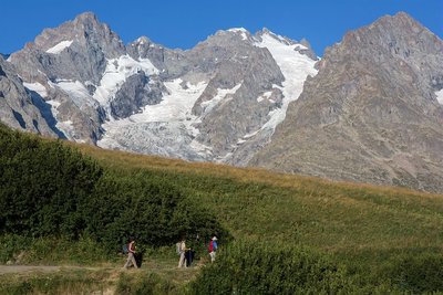
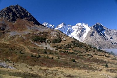
Vue sur la Meije depuis le sentier des Crevasses - © Parc national des Écrins - Pascal Saulay  Glacier
View over La Meije
La Meije is the second major peak in the Massif des Ecrins. It is made up of 3 main peaks: the Doigt de Dieu (3,973 m), La Meije Orientale (3,891m), and the highest summit, the Grand Pic at 3,983 m. It is a hard summit to climb, and the first to do so, on 16 August 1877, was Emmanuel Boileau de Castelnau, together with the famous local guide, Pierre Gaspard. "Meije" comes from the Occitan word Meidjo, which means midday, because when seen from the village of La Grave, the sun passes above the summit at around noon. On the other side, before La Meije became famous, it was called the Bec des Peignes (“Comb Beak”) by the inhabitants of Saint-Christophe-en-Oisans.
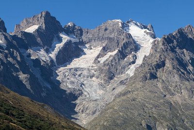
Vue sur le glacier du Lautaret et de l'Homme depuis le belvédère de l'homme - © Parc national des Écrins - Cyril Coursier  Panorama
Belvedere de l'homme
A wooden guardrail is set up at the ideal spot for contemplating the descending glaciers of La Meije. The Lautaret glacier to the left and the Glacier de l’Homme to the right scarcely meet today. The last-named glacier is the descending ski slope from the Pic Oriental of La Meije and from the Aigle refuge (to be seen if you continue along the path towards the Rocher Blanc). The refuge is perched at an altitude of 3,450 m on a rocky spur. A new refuge was opened in 2014, preserving an existing wooden structure that dated from 1910.
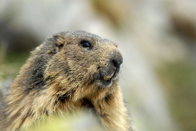
Marmotte au printemps - PNE - Papet Rodolphe FaunaThe marmots’ "bosse"
The alpine marmot is naturally present on grass at altitude. Here, it occupies a singular place which we call the marmots’ "bosse». This hibernating rodent is only visible between April and October. The marmot lives in a family and respects a hierarchy. Games, grooming, fighting and biting ensure the dominance of a couple as well as the cohesion of the group. Each animal participates in the delimitation of the territory by rubbing its cheeks on rocks and also by urinating and defecating there. When there is danger, the marmot emits a high and powerful whistle in order to warn the others.
Altimetric profile
Information desks
Information center "Col du Lautaret" (summer only)
Col du Lautaret, 05220 Le Monêtier-les-bains
Under the gaze of the Meije (3983 m) and surrounded by beautiful meadows celebrated in the great names of botany, the former hospice of the Lautaret called "refuge Napoleon" houses the reception and information Park center - Projections, documentation, books of the Park. Accessible to people with reduced mobility. Free admission.
Source

Report a problem or an error
If you have found an error on this page or if you have noticed any problems during your hike, please report them to us here: