
3. From the Refuge de l'Olan to the Refuge du Clot Xavier Blanc
The descent looking down over La Chapelle gives the impression of walking on the edge of the void, while a tour of the village nestling at the feet of the mountains takes you on a journey back in time before you tackle the ascent up to the Refuge de Xavier Blanc with its pastoral surroundings. This is what gives this trail its unique character.
Tommy Bulle
Description
- Continue downhill. The path leads to another footbridge. After the last twists and turns you have earned the satisfaction of arriving at the bottom of this descent.
- At the road, turn right and continue straight on to the centre of the village.
- At the intersection, turn left and then right at the next intersection. You then join the "Pays du Tour du Vieux Chaillol" GR , which you follow until you reach the refuge. The path runs along the left-hand bank of the Séveraisse. This used to be the access route for the hamlets higher up the mountain. A few structures, dry stone walls, pavings and old bridges testify to human presence in centuries past. The hamlet of Le Casset is on the opposite bank. A kilometre further on, you arrive at the hamlet of Le Bourg.
- Cross the river and carry on along the right-hand bank. The path rises gradually until it comes to the hamlet of Le Rif du Sap: go through the hamlet.
- From this point, the path leads rapidly to the Refuge du Clot Xavier Blanc.
- Departure : Refuge de l'Olan
- Arrival : Refuge Xavier Blanc
- Towns crossed : La Chapelle-en-Valgaudemar
14 points of interest
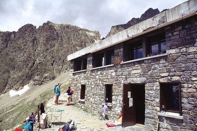
Façade du refuge de l'Olan - Claude Dautrey - PNE  Hut
HutOlan Refuge
Situated at an altitude of 2350 m, this large building constructed in 1957 was carried away by an avalanche two years later. A witness to this is a concrete slab below the refuge. Rebuilt in 1966, it was definitively extended in 1978 with a capacity of 54 places. A stage of the Tour de l'Oisans (GR 54), it welcomes hikers in the summer season and provides a shelter in the winter; it belongs to the Club Alpin Français.
 Vernacular heritage
Jas crossing of the Bourelle
Just above the signpost, there are the ruins of a pasture shelter commonly called the, « jas ». Often built using dry stones, this kind of shelter was used to protect the flocks during the summer season.
Passerelle franchissant la gorge de la Bourelle - Dominique Vincent - PNE  Geology and geography
Bourelle Gorge
Since the end of the ice age, water has carved the rock and the passage of materials has created a small gorge polishing the base rock (gneiss, micaschists). The National Park has taken on the challenge of building a wooden walkway for walkers to cross this gorge.
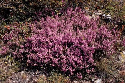
Callune vulgaire - Daniel Roche - PNE  Flora
FloraHeather fields
Over a change in altitude of a hundred metres there is a covering of heather which provides pollen for the bees and purple colour in Autumn, A small persistent shrub with tiny leaves and little pink flowers, it is called Common Heather or False Heather.
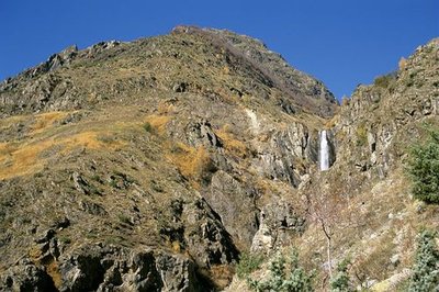
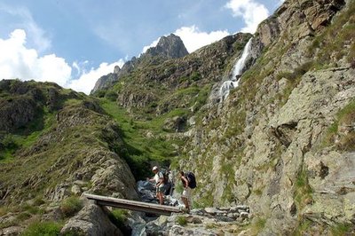
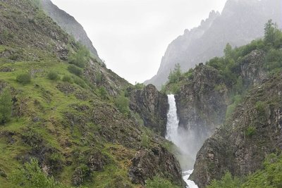
La cascade de Combefroide - Olivier Warluzelle - PNE  Water
WaterCombefroide Waterfall
At the beginning of the path, is a big waterfall that you can approach on a narrow footpath just before climbing the coast. Situated on Combefroide torrent at a rocky escarpment, this waterfall has several projections and presents a total drop of several dozen metres.
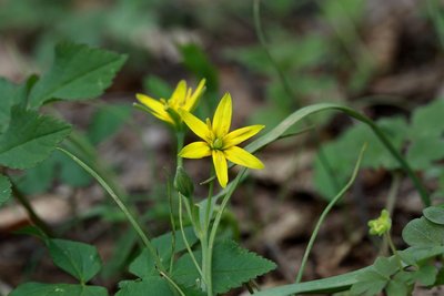
Gagée jaune - Cédric Dentant - PNE FloraHayfields
Hayfields surround the village of La Chapelle. Unfortunately, such natural hayfields, and their flowers and insects, are more and more frequently replaced by temporary hayfields, in other words, certain years they are sowed. These prairies are still watered by the irrigation canals that are well maintained by the users with the help of the National Park. You will see the floodway of the Grande Levée canal not far from the stream as it nears the Sèveraisse. The canals are of great importance for preserving wetland flora, such as alternate-leaved golden saxifrage or yellow star-of-Bethlehem, both of which are protected species.
La cascade de Combefroide - Olivier Warluzelle - PNE  Panorama
Waterfalls and view points over the valley
Along the itinerary, you will see the Combefroide and Casset waterfalls that are situated on the south facing slopes of the valley. The route also gives a good view to the east and the west of the Sèveraisse valley from the hamlet of Casset. Downstream, from the hamlet of Rif du Sap, a good example of a U-shaped valley is proof of shaping by the quaternary glaciers.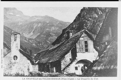
Chapelle et maisons du hameau du Clot avant l'incendie de 1934 - Jean-Claude Catelan (collection)  History
An itinerary packed with history
The Casset bridge is the oldest remaining bridge over the Sèveraisse that has not been washed away by floods. On the right bank of this magnificent "Roman" structure, the hamlet of Casset gets its name from the "casse" (large steep scree deposits at the foot of slopes) that surround it. This village, like that of Le Bourg, was partly covered by a landslide. As for Le Rif du Sap, an avalanche swept away the houses from the top of the hamlet in 1944. The hamlet of Le Clot, was flooded in 1928, and was totally abandoned in 1934 when a fire destroyed most of the dwellings.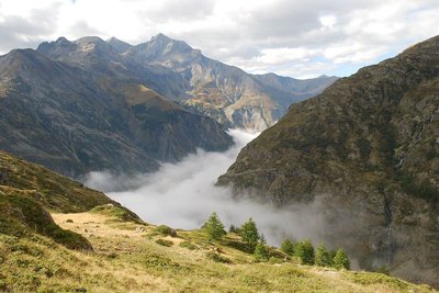
Itinéraire de Tirière vue sur la vallée de Valgaudemar - Olivier Warluzelle - PNE HistoryToponymy in the Valgaudemar area
Valgaudemar! The sound of this name resonates in our ears. Some claim that it is in reference to the valley of Mary "Gaude Marie" or "Rejoice Mary!" It is more reasonable to think that it is in reference to Gaudemar, the last king of the Burgundians (524) a Germanic tribe that invaded this area in 406...Vallis Gaudemarii can be read in texts as early as 1284. Poetic licence, legends and imagination are often red herrings when it comes to researching the origins of names.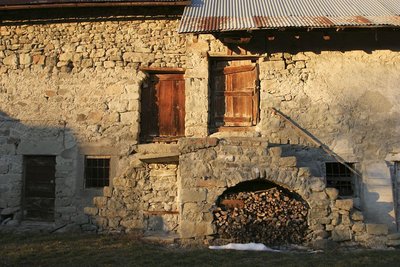
Maison aux portes, Valgaudemar - Stephan D'houwte - PNE  Architecture
Traditional dwellings
A few typical, old Valgaudemar houses can be seen in the hamlets of Casse, Le Bourg and Le Rif du Sap. A few thatched roofs, vaulted entrances to dwellings ("tounes"), and stone paving, are some fine examples of architecture that are worth saving. Cheaper and requiring less maintenance, sheet metal gradually replaced the thatch on the rooftops.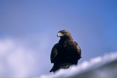
Aigle royal - Robert Chevalier - PNE  Fauna
FaunaGolden eagle
Between La Chapelle and Le Clot, it is not rare to see the golden eagle flying over the sunlit slopes. In the summer, this majestic bird of prey with its dark plumage (some have lovely white rosettes on the underside of their wings) mingles with the short-toed eagle, which is smaller and lighter-coloured, and the griffon vulture, which is larger, with a short tail and often flies in groups. There is nothing surprising about this as the south facing slopes provides thermal lift that enables them to fly high and far.
Architecture traditionnelle - Yves Baret - PNE Architecture"Toune"
This is an architectural feature of the Champsaur-Valgaudemar area and is the barrel-vaulted porch on the main facade of the house. It sheltered the entrance to the dwelling and stable and was sometimes used to stock items, such as wood, to keep it dry. The "toune" was often painted white to reflect the sunlight. They inhabitants would sit in them to do embroidery or darning, etc.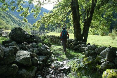
Via Clause du Clot - Dominique Vincent - PNE Vernacular heritageWalled paths
On certain stretches of the route, you will walk between two stone walls. Such "via clause" were built to stop the domestic animals, on their way up to the pastures, from walking on or eating the grass in the prairies that was intended for them in the winter. The most remarkable "via clause" is on the way out of the hamlet of Le Clot. It has been restored by the Ecrins National Park.
.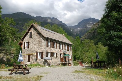
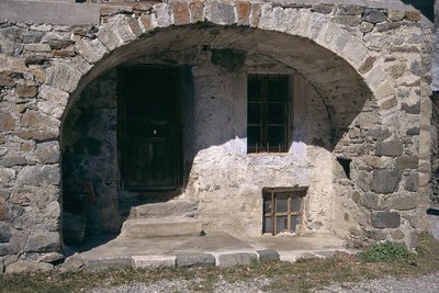
Refuge du Clot Xavier Blanc - Dominique Vincent - PNE HutClot Xavier Blanc mountain refuge
What a strange idea to build this mountain refuge below the road leading to Gioberney, at an altitude of "only" 1397 m. In fact, it was already there more than a century ago, long before the road was built. This simple, sturdy building belonged to the Valgodemar Mining Company that operated in the area extracting copper and lead. When the business closed, the Club Alpin Français bought the building and named it after Xavier Blanc, in recognition of one of the founder members of the CAF, senator of the Hautes Alpes.
Altimetric profile
Sensitive areas
Golden eagle
- Impacted practices:
- Aerial, , Vertical
- Sensitivity periods:
- JanFebMarAprMayJunJulAug
- Contact:
- Parc National des Écrins
Julien Charron
julien.charron@ecrins-parcnational.fr
Bearded vulture
- Impacted practices:
- Aerial, , Vertical
- Sensitivity periods:
- JanFebMarAprMayJunJulAugNovDec
- Contact:
- Parc National des Ecrins - Yoann Bunz- 06 99 77 37 65 yoann.bunz@ecrins-parcnational.fr
Recommandations
Take care when descending from the Refuge de l'Olan, especially in wet weather.

Information desks
Valgaudemar Park house
Ancien Asile Saint-Paul, 05800 La Chapelle-en-Valgaudemar
Information, documentation and a reception area with permanent and temporary exhibitions. La Maison du Parc is labeled "Tourism and Disability". Free admission. All animations of the Park are free unless otherwise stated.
Source

Report a problem or an error
If you have found an error on this page or if you have noticed any problems during your hike, please report them to us here: